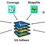
There are many types of GIS data formats. Shapefiles are one of the popular ones.Several format options are described below.Shapefiles (SHP) – This is probably the most common data format, and almost any GIS-enabled software can read a shapefile. A SHP typically consists of four file … [Read more...] about Types of GIS Data Formats
GIS
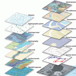
Spatial Data Formats
Information Type Preferred Format Extension Comments CAD (Computer Aided Design) Data AutoCAD Drawing file DWG Shall be compatible with AutoCAD Release 2007 GIS Data ESRI Shapefile SHP, SHX and DBF GIS Data Geodatabase oracle spatial SQL server SAP ESRI personal geodatabase Digital Elevation Models Band Interleaved by … [Read more...] about Spatial Data Formats