AutoCAD 2021 New Commands and System Variables New commandsDescriptionAutoCADAutoCAD LTBREAKATPOINTBreaks the selected object into two objects at a specified point.XXDWGHISTORYOpens the Drawing History palette, which displays a version history of the current drawing as maintained by a supported cloud storage provider.XXDWGHISTORYCLOSECloses the Drawing History … [Read more...] about AutoCAD 2021 New Commands and System Variables
AutoLISP lives on – Improvements in AutoCAD 2021
AutoLISP has been around for a long time. But it is still a great tool to create programs inside of AutoCAD. The latest release of AutoCAD 2021 has made a couple of improvements to the AutoLISP and DCL environments. We take this as a commitment from Autodesk this oldie is still a goodie. AutoLISP Improvements Improvements have been made to AutoLISP and DCL. These … [Read more...] about AutoLISP lives on – Improvements in AutoCAD 2021
XREF Compare – New to AutoCAD 2021
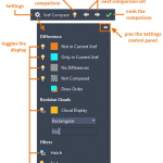
New to AutoCAD 2021, you can now compare the changes made to an XREF in the current drawing. Any changes to the xref or compared drawing are highlighted using revision clouds. If a referenced drawing has changed, a balloon message is displayed in the lower-right corner of the application window (the status bar tray). Click the link in the balloon message to reload the … [Read more...] about XREF Compare – New to AutoCAD 2021
How to automatically set the drawing to load acadiso.lin linetype?
Worked on: AutoCAD 2019 Date: 26 March 2020 Problem Trying to load linestyles, in the layer dialog box for a metric drawing, but the imerpial linetype file is set as a deafult (acad.lin). How can I change this so the metric one (acadiso.lin) is the default linetype? Solution Set MEASUREMENT and MEASUREINIT to 1 Screen Shots Layer linetype default set to … [Read more...] about How to automatically set the drawing to load acadiso.lin linetype?
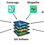
Types of GIS Data Formats
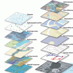
There are many types of GIS data formats. Shapefiles are one of the popular ones.Several format options are described below.Shapefiles (SHP) – This is probably the most common data format, and almost any GIS-enabled software can read a shapefile. A SHP typically consists of four file … [Read more...] about Types of GIS Data Formats
Spatial Data Formats
Information Type Preferred Format Extension Comments CAD (Computer Aided Design) Data AutoCAD Drawing file DWG Shall be compatible with AutoCAD Release 2007 GIS Data ESRI Shapefile SHP, SHX and DBF GIS Data Geodatabase oracle spatial SQL server SAP ESRI personal geodatabase Digital Elevation Models Band Interleaved by … [Read more...] about Spatial Data Formats